This ride is not flat at all. It goes through San Elijo hill with over 1580 ft. total climb.
As seen the map, I rode my bike from home to San Marcos Blvd, to Rancho Santa Fe, and at about 4.5 miles I turned into San Elijo Rd. which climbs up the San Elijo hill (see the satellite photo), and at about mile 8 I started descending down until I reached Craven Rd. which I took left to Discovery Rd. back home. The total tour is 11.44 miles and took one hour and 41 minutes as is shown in the statistics on the map. It is quite a workout (927 calories burnt in the effort). The map and its details are taken by the RunKeeper app on my phone.
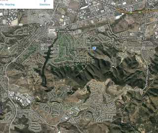
The satellite photo shows the same map with the details of the San Elijo hill shown clearly. The distance up to mile 4 was more or less flat, but then starting at San Elijo Rd. you see that the road goes up the hill. I looked back while riding the bike and I could see the ocean behind me, a view that most houses on the hill can see. San Elijo Rd. becomes Twin Oaks Rd., and it meets Craven Rd. as you see in the satellite photo. The path from Craven Rd. to S. Bent Avenue is more or less flat, then left on to Discovery Rd. which is also flat. Finally I took the Vera Cruz Rd. back home and that has some climbing in it which provides a nice workout near the end of the exercise. Can you see Lake San Marcos within the trip's loop?


No comments:
Post a Comment